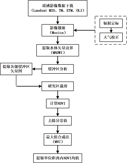
<p>This data is NDVI grid data of the Aral Sea lake from June to October every year in 1977, 1987, 1997, 2007 and 2017. The projection uses UTM projection, WGS-8 coordinate system, spatial resolutions are 30m and 60m, and temporal resolution is month. </p>
| collect time | 1977/01/01 - 2017/12/31 |
|---|---|
| collect place | Aral Sea |
| data size | 10.8 GiB |
| data format | raster data |
| Coordinate system | WGS84 |
| Projection | UTM |
The raw remote sensing data mainly comes from the United States Geological Survey (USGS) Landsat satellite remote sensing images.
Use the NDVI tool in the ENVI 5.3 Toolbox to calculate the band of the images in the study area. The formula is NDVI=(NIR-R)/(NIR+R), where NIR is the near-infrared band and R is the red light band. Select the calculated bands in the NDVI tool and output the results, and finally get the NDVI values for each month within the buffer zone. Use the Maximum Value Composite (MVC) formula: MaxNDVI_i=Max(NDVI_1, NDVI_2, NDVI_3, NDVI_4), where: MaxNDVI_i represents the maximum monthly NDVI value; i is the month, with values ranging from 5 to 10; and [NDVI]_1-[NDVI]_4 respectively represent the NDVI values of raw images after preprocessing in the corresponding month. Obtain the NDVI values during the growing season in the study area, calculate the mean NDVI within a unit distance, and use the grid calculator in ArcGIS10.2.2 to calculate the mean NDVI values for each month in the growing season.
The 1977 image is a first-level data product of the Landsat1-5 Multispectral Scanner (MSS), with a spatial resolution of 60m and a temporal resolution of 18d. Images from 1987, 1997, and 2007 are first-level spectral data products from the Landsat4 and Landsat5 thematic mappers (TM) with a spatial resolution of 30m and a temporal resolution of 16d. The 2017 image is a first-level multispectral data product from andsat8 OLI(Operational Land Imager) and TIRS(Thermal Infrared Sensor), with a spatial resolution of 30m and a temporal resolution of 16d. The spatial resolution of the processed data accuracy is the same as the original data, and the temporal resolution is months and years.

| # | number | name | type |
| 1 | XDA20000000 | Other |
This work is licensed under a
Creative
Commons Attribution 4.0 International License.
| # | title | file size |
|---|---|---|
| 1 | Data.rar | 10.8 GiB |
©Copyright 2021-. Xinjiang Institute of Ecology and Geography, CAS
No. 818 Beijing South Road, Urumqi, Xinjiang, China, 830011