
<p>This dataset is 10M resolution vector data of crop planting structure in the Nukus Irrigation District of Uzbekistan in 2019. The data includes 12 major planting structure categories such as water area, corn, rice, wheat, cotton,(garden, grapes, apples, alfalfa, peach trees),(forest land, mulberry tree),(abandoned land, fallow land, reclaimed land, wasteland),(greenhouses, vegetables, alfalfa, hops), saline-alkali land, desert, grassland, etc., and planting area information is stored in shp vector format. </p>
Sentinel data.
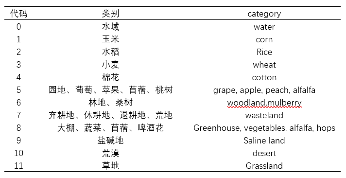
The planting structure is calculated on the GEE platform using random forest algorithm and combined with collected sample point data. For convenience of differentiation, during the calculation process, we represent each similar crop type with an Arabic numeral, and the calculated.tif results are then linked to the extracted cultivated land by zoning statistics. During this process, we retain the field representing the crop type, namely the max field. The crop type corresponding to each Arabic numeral is shown in the following table:
Kappa coefficient 80%
| # | number | name | type |
| 1 | XDA20000000 | Other |
 This work is licensed under a
Creative
Commons Attribution 4.0 International License.
This work is licensed under a
Creative
Commons Attribution 4.0 International License.
 CSTR:33110.11.ariddc.00282
 10.12389/ariddc.00282

